Use the Prescient SDK client for searching and accessing raster data#
import pystac_client
import rasterio
from rasterio.session import AWSSession
from rasterio.plot import show
import matplotlib.pyplot as plt

from prescient_sdk.client import PrescientClient
Create the Prescient SDK client and use it to open the STAC catalog#
# creates the Prescient SDK client using a configuration file
client = PrescientClient(env_file="c:/path/to/config.env")

# opens the STAC catalog using the Prescient SDK client's configuration
# note that this will open your default browser, and prompt you to log in if you are not already logged in
catalog = pystac_client.Client.open(client.stac_catalog_url, headers=client.headers)
catalog.title
Search the STAC catalog#
There are many potential methods available to search for an item or a set of items cataloged in STAC
See the pystac-client documentation for more complex examples: https://pystac-client.readthedocs.io/en/stable/usage.html
# this search is just returning the first STAC item in the catalog
results = catalog.search(max_items=1)
items = list(results.items())
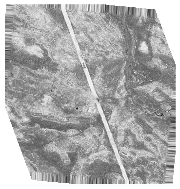
Access the STAC item using Rasterio#
The item found in the STAC search (previous cell) can be accessed from the S3 bucket in AWS
The client provides an AWS Session which can be used by rasterio to access AWS resources
Using rasterio you can access, process, and manipulate the data
# fetch the item URI and open it with rasterio
fig, ax = plt.subplots()

rasterio_session = AWSSession(client.session)

with rasterio.Env(session=rasterio_session) as env:
    for item in items:
        asset = item.assets["INT"]
        with rasterio.open(asset.href) as src:
            ax = show(src, ax=ax, cmap="gray")
            ax.set_axis_off()